|
MyCen Directions: Stesen Sentral, KL Sentral, Kuala Lumpur
|
Driving guide & ground directions with road maps, street pictures & information of the route, location or area
|
| Find Other Places: Directions & Map Index | Search For A Location | More Maps Here |
|
|
 MyCen Directions
Updated & Current
Clear & Accurate Maps
With Latest Landmarks
GPS Verified On Ground
Portal-Wide Useful Links
Picture Of Every Location
Comprehensive Information
Made With Local Knowledge
Each Place Visited In Person
Satellite & Google Earth View
Independent Opinion & Review

As Seen On TV's

|
Sentral Station, KL Sentral, Brickfields, Kuala Lumpur
|
|
|
|
If interactive map above is slow to load or not showing, CLICK HERE for static view
|
|
|
|
|
| View the Full MyCen Events Calendar here |
|
Address: Stesen Sentral Kuala Lumpur, Jalan Stesen Sentral, Kuala Lumpur, Malaysia
Postcode (Poskod): 50470 Kuala Lumpur
Tel: +603 2773 8888 (General Line), +603 2773 8899 (Information Line)
Fax: +603 2260 3306 (Building Services Division, MRCB)
Website: http://www.stesensentral.com/
Area: Wilayah Persekutuan Kuala Lumpur, Federal Territory of Kuala Lumpur (KL / WP)
Jurisdiction: Dewan Bandaraya Kuala Lumpur DBKL - KL City Hall (See Local Govt)
Events At This Location: See MyCen Events Calendar
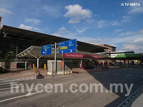
Directions: The KL Sentral complex can accessed by various roads. You can enter via Brickfields, by Jalan Mahameru or by Jalan Travers, opposite the National Museum.
Info / Insights: Stesen Sentral (Sentral Station) is often erroneously (and understandably) referred to as KL Sentral. This transportation hub sits within the KL Sentral project; a 'city within a city' concept designed by renowned architect Dr Kisho Kurokawa. The master plan comprises of office towers, international hotels, luxurious condominiums, shopping malls and an international exhibition & convention center.
The almost 1 million sq ft terminal functions as a convenient and centralised transit terminal by connecting rail lines of the LRT (Putra) system and train lines of KTM Komuter / Intercity system.
There is an unfortunate quirk though. The KL Monorail stops short of the terminal and passengers will need to lug their bags for about 200 metres, crossing busy Jalan Tun Sambanthan. While it is great the budget LCCT buses are also functioning from Stesten Sentral, the accompanying touts add a rowdy and chaotic touch to the otherwise futuristic terminal.
KLIA-bound travelers can also use the 'bullet train' type KLIA Express. The trains take off from Kuala Lumpur City Air Terminal (KL CAT or Terminal Udara KL). It bears the IATA code of XKL and air passengers can check in their luggage directly here.
As with many of our transport terminals, tourists and locals need to be protected from the predatory cabbies via a coupon system.
What was once a huge railway yard, is fast shaping up as the modern city envisioned by the developers of KL Sentral (http://www.klsentral.com.my/) . The completed buildings (and tenants) include:
KL Sentral Station (http://www.stesensentral.com/)
KL Hilton (http://www.hilton.com.my/) (1)
Le Meridien Hotel (http://www.starwoodhotels.com/lemeridien/) (2)
City Air Terminal (KL CAT) - Terminal Udara KLIA Ekspres (http://www.kliaekspres.com/) (3)
Sooka Sentral (http://www.sookasentral.com/) (5)
Quill 7 (7)
Menara SSM - Suruhanjaya Syarikat Malaysia (http://www.ssm.com.my/) (8)
Mercu UEM (http://www.uem.com.my/) (11)
Plaza Sentral (12)
1 Sentral (13)
Suasana Sentral Loft (http://www.ssloft.com/) (15)
Suasana Sentral Condo (16)
Related: Hentian Puduraya | Hentian Duta | Hentian Putra | Pasar Rakyat Terminal | LCCT
Nearby Landmarks: Hilton KL (1), Le Meridien Hotel (2), KL City Air Terminal - KLIA Ekspres (3)
Surrounding Places: New Travers Police Station (4), Sooka Sentral (5), Plaza Sentral (6), Quill 7 (7), Menara SSM - Suruhanjaya Syarikat Malaysia SSM - Commission of Companies (8).
Mercu UEM (11), Plaza Sentral (12), 1Sentral (13), Suasana Sentral Loft (15), Suasana Sentra Condo (16), Poslaju Brickfields (17),
Hotel Florida (21), KL Sentral Monorail Station (22), Sentral Hotel (23), Mexico Hotel (24), Brickfields College (25), Mobil Station (26),
YMCA KL (31), Hotel Summer View (Bangunan JK Lim) (32), Malaysian Association for the Blind (MAB) (33), Tun Sambanthan Monorail Station (34), Wisma Monorail (35), Bangunan Siewdor Mansion - Siew Dor Flats (36),
633 Residency Condominium (51), Kalamandapam Hindu Temple & Hall (Scott Road Temple) (52), Villa Scott Condo (53), Muzium Negara - National Museum (61), Sri Bukit Persekutuan, Federal Hill (62), Institut Pengurusan Kesihatan (63),
(use zoom and navigation buttons on top left of map to explore)
Surrounding Roads: Jalan Stesen Sentral, Jalan Travers, Jalan Tun Sambanthan, Jalan Damansara, Jalan Scott, Jalan Sultan Abdul Samad, Jalan Padang Belia, Jalan Tebing, Jalan Selangor, Jalan Syed Putra, Jalan Bangsar
Nearby Hotels: Hilton KL (1), Le Meridien Hotel (2), Hotel Florida (21), KL Sentral Monorail Station (22),
Mexico Hotel (24), YMCA KL (31), Hotel Summer View (Bangunan JK Lim) (32),
(For telephone contact, full address & web site of individual hotel, see our Hotel Listings)
Nearest Train Station: Inside: KL Sentral LRT Staion, KL Sentral KTM Station, KLIA Express Station
Outside: KL Sentral Monorail Station (22),
Tun Sambanthan Monorail (34)
Nearest Police Station: Balai Polis Travers (4)
Bus Number:
Distance:
GPS Coordinates & Position: N3 08.055 E101 41.185
Featured Category : Land Transport
Related Categories: Hotels | Properties | Tourism | Airlines
Connecting Maps: YMCA KL | Brickfields Buddhist Temple | KL Bird Park, Lake Gardens
Wisma Belia | Dataran Merdeka | Kampung Attap | Jalan Duta
|
|
|
| Find Other Places: Directions & Map Index | Search For A Location | More Maps Here |
Please help us refine the location information by sending additional info, suggestions, updates, comments to tvsmith@mycen.com.my
Maps powered by Google Maps unless otherwise stated. Additional geographical information, overlays, placemarks, waypoints, data, pictures and design created & owned by Malaysia Central & TV Smith. All rights reserved. No warranty on validity, completeness or accuracy given or implied. Use at your own risk. Property names, place names, location mark, point-of-interest, business names, designs, signs, graphics, symbols, icons, brands & logos are trademarks of their respective owners. |
| queries: photo, pics, image, gis, place, places, attraction, guide, streetmap, roadmap, building, site, streets, directory, roads, public transport, travel, get, go, going, getting, drive, driving, walk, direction, journey, lrt, ktm, cab, whereabouts, locate, about, how to go, where is, far, near, shortest, find, miles, from, lokasi, gambar, tempat, cari, cara, macam mana, di mana, bagaimana, pergi, ke, jalan, bangunan, wisma, teksi, peta, panduan, arahan, arah memandu, pandu, alamat, tapak, berdekatan, perjalanan, dari, laluan |
|
|
|
|