|
MyCen Directions: Hentian Putra Bus Terminal
|
Driving guide & ground directions with road maps, street pictures & information of the route, location or area
|
| Find Other Places: Directions & Map Index | Search For A Location | More Maps Here |
|
|
 MyCen Directions
Updated & Current
Clear & Accurate Maps
With Latest Landmarks
GPS Verified On Ground
Portal-Wide Useful Links
Picture Of Every Location
Comprehensive Information
Made With Local Knowledge
Each Place Visited In Person
Satellite & Google Earth View
Independent Opinion & Review

As Seen On TV's

|
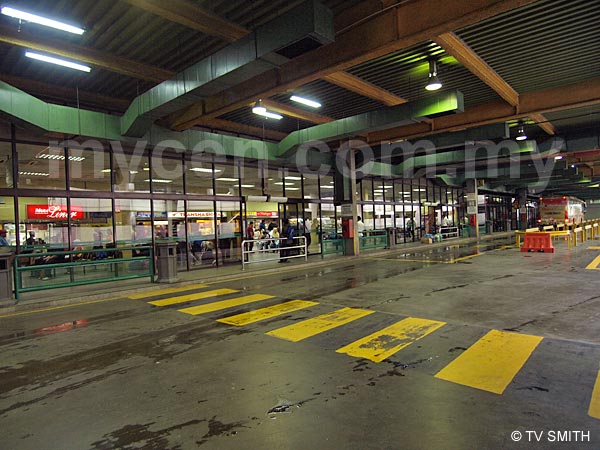
Hentian Putra - Stesen Bas
|
|
|
|
|
|
|
|
|
| View the Full MyCen Events Calendar here |
|
Address: Junction of Jalan Putra and Jalan Tun Ismail, Kuala Lumpur, Malaysia
Postcode (Poskod): 50480 Kuala Lumpur
Tel:
Fax:
Website:
Area: Wilayah Persekutuan Kuala Lumpur, Federal Territory of Kuala Lumpur (KL / WP)
Jurisdiction: Dewan Bandaraya Kuala Lumpur DBKL - KL City Hall (See Local Govt)
Directions: From the Bank Negara junction, take Jalan Kuching and exit into PWTC. When driving from Jalan Pahang or Jalan Tun Razak, go up the flyover at the Jalan Ipoh interchange and turn left after the Bomba. PWTC will be on your left and Hentian Putra on your right. The entrance to the car park is at the traffic light junction where The Mall is located. You can also take Jalan Raja Laut (one-way) and turn left at the Chow Kit junction.
Info / Insights: Hentian Putra is much smaller than its counterparts, Hentian Duta, Hentian Puduraya and Hentian Pasar Rakyat. This city bus terminal caters mainly to express buses serving the east coast states of Pahang, Terengganu and Kelantan. Like the other two terminals, there is no proper information counter. The security post doubles up as one and there is no phone number available for enquiries.
"Reps" from the various bus companies are quick at approaching potential passengers. They are quite polite and less aggressive than those at Puduraya though.
The station is operated by City Hall and parking is available on the same building. Amenities include a baggage storage service, snack kiosks and a surau. There is also a taxi stand at the back of the building.
Note that if you enter the terminal via the traffic light junction to drop a passenger, the only way out is via the multi-storey carpark. A flat "toll" of 3 ringgit applies even if you just want to pass through (to get out).
Related: Stesen Sentral | LCCT | Hentian Bas Sementara Hang Tuah | Bukit Jalil
Nearby Landmarks: PWTC - Putra World Trade Centre (A), Menara Dato Onn - UMNO Building (B), The Mall (Putra Place) (C)
Surroundings Places: Legend Hotel (D), Best Western Premier Seri Pacific Hotel (E), Villa Putera & Puteri Condo (F), Sri Bukit Tunku Condo (G), Horizon School (H), 9 Lorong Tun Ismail Gated Homes (I), Sutera Bukit Tunku Condo (J), Rumah Sarawak (K), Open University Malaysia (OUM) Campus & Universiti Malaya (UM) Kampus Kota (N), Grand Central Hotel (O), Hotel Putra (P), De First Inn (Q), City Hotel (R), Bistari Condo - Lavender & Begonia (V), Old Federal Cinema (X), Pasaraya Wan Lee Heng (Old Capitol Cinema) (Y), Grand Seasons Hotel (Z)
(use zoom and navigation buttons on top left of map to explore)
Surrounding Roads: Jalan Putra, Jalan Chow Kit, Jalan Kuching, Jalan Mahameru, Jalan Ipoh, Jalan Raja Laut, Jalan Tuanku Abdul Rahman, Jalan Tun Ismail, Jalan Tiong Nam, Jalan Haji Taib, Jalan Sri Amar, Jalan Pahang
Nearby Hotels: Seri Pacific Hotel (formerly Pan Pacific) (E), Legend Hotel (D), Grand Central Hotel (O), Hotel Putra (P), De First Inn (Q), City Hotel (R), Puteri Park Hotel (S), Citrus Hotel (T), Grand Seasons Hotel (Z)
(For telephone contact, full address & web site of individual hotel, see our Hotel Listings)
Nearest Train Station: PWTC LRT Station, Putra Halt KTM Komuter Station (both walking distance)
Nearest Police Station: Balai Polis Sentul, Tel: 03 4042 2222
Bus Number:
Distance: 3.6 km to Hentian Duta via Jalan Kuching
GPS Coordinates & Position: N3 10.041 E101 41.431
Featured Category : Land Transportation
Related Categories: Taxis | Travel | Airlines | Hotels | Shopping Malls | Properties
Connecting Maps: Citrus Hotel, Tiong Nam | McCurry Restaurant, Jalan Ipoh
Asian Heritage Row,
Jalan Doraisamy | HGH Convention Centre, Sentul
Vistana Hotel, Damai Complex |
|
|
| Find Other Places: Directions & Map Index | Search For A Location | More Maps Here |
Please help us refine the location information by sending additional info, suggestions, updates, comments to tvsmith@mycen.com.my
Maps powered by Google Maps unless otherwise stated. Additional geographical information, overlays, placemarks, waypoints, data, pictures and design created & owned by Malaysia Central & TV Smith. All rights reserved. No warranty on validity, completeness or accuracy given or implied. Use at your own risk. Property names, place names, location mark, point-of-interest, business names, designs, signs, graphics, symbols, icons, brands & logos are trademarks of their respective owners. |
| queries: photo, pics, image, gis, place, places, attraction, guide, streetmap, roadmap, building, site, streets, directory, roads, public transport, travel, get, go, going, getting, drive, driving, walk, direction, journey, lrt, ktm, cab, whereabouts, locate, about, how to go, where is, far, near, shortest, find, miles, from, lokasi, gambar, tempat, cari, cara, macam mana, di mana, bagaimana, pergi, ke, jalan, bangunan, wisma, teksi, peta, panduan, arahan, arah memandu, pandu, alamat, tapak, berdekatan, perjalanan, dari, laluan |
|
|
|
|