MyCen Maps
Related: Country
Info | Places
| Communities
| Hotels
| Restaurants
| Nightlife
| Highways
| Tourism
| Transport
| Shopping
Malls | Properties
| Theme
Parks
Retailers
| Banks
| Corporations
| History
| Petrol Companies
| Motoring
| Car Rental
| Taxi
| Venues
| Recreation
Clubs | Outdoor
Adventure
ENTRY PAGE | MAP INDEX | DIRECTIONS | LOCATIONS | VIRTUAL TOURS | SEARCH | HELP | MORE MAPS HERE
Link to this resource: http://www.mycen.com.my/map | Please read terms & conditions below
before using
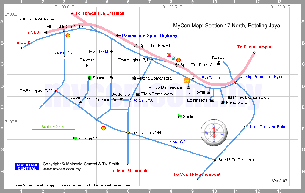
MyCen Map: Section 17 North, Petaling
Jaya, Selangor
Zoom Out to: Petaling Jaya Oveview
Nearby: Upper
Damansara | Lower
Damansara | KL
City Center | KL
City East | KL
City North | Klang
Valley North East | Petaling Jaya
Map Area: Seksyen 16 & 17, PJ, Petaling Jaya,
Selangor, Sprint Highway, Jalan Damansara, Kuala
Lumpur
Apartments,
Condominiums, Flats
Astana Damansara D6,
Tiara Damansara D6,
Banks, ATMs
Southern
Bank Section 17 Branch D4,
Cemeteries
Muslim Cemetery A2,
Commercial Buildings, Office Towers
CP Tower D10,
Menara
Star E10,
Phileo Damansara 1 D9,
Phileo Damansara 2 E11,
Commercial Areas
Sentosa Area (around the former Sentosa
Cinema) C4,
Exits
To Jalan Universiti H6,
To Kuala Lumpur B12,
To NKVE
(New Klang Valley Expresway) A2,
To Sec 16 Roundabout H9,
To SS 2 B1,
To Taman Tun Dr Ismail (TTDI) A3,
Hotels
Eastin
Hotel E10,
|
Others
Addaudio
Studios E6 (see Custom
Map),
Petrol, Gas Stations
BHP
Sprint Slip Road D9,
Petronas
Sprint Highway (Jalan Damansara) C8,
Shell
Jalan 17/21 B3,
Shell
Jalan 17/22 F5,
Shell
Sprint Highway (Jalan Damansara) C8,
Recreation Clubs, Golf Clubs
KLGCC
(Kuala Lumpur Golf & Country Club) C10,
Restaurants, Food Courts, Fast Food,
Eating Places
Decanter
Restaurant E5,
Dunkin Donut (Petronas Station Annex) C8,
Roads, Highways, Expressways, Interchange,
Junctions
Jalan 16/6 G8,
Jalan 17/1 C7,
Jalan 17/21 C3,
Jalan 17/22 D3,
Jalan 17/29 E4,
Jalan 17/33 B5,
Jalan 17/56 D6,
Jalan Dato Abu Bakar F11,
Sprint
Damansara Toll Plaza A To Taman Tun C8,
Sprint
Damansara Toll Plaza B To NKVE & SS2 B6,
Sprint
Slip Road (Toll Bypass) D11,
|
|
Link to this resource: http://www.mycen.com.my/map
ENTRY PAGE
| MAP INDEX | DIRECTIONS |
LOCATIONS |
VIRTUAL TOURS
| SEARCH
| HELP | MORE MAPS HERE
This map, its embedded geographical information, data
and design are created & owned by Malaysia Central
& TV Smith. You may link, save, display, print
or circulate this map for personal use on condition
it is not altered or modified. Attribution to Malaysia
Central including its logo, url, watermark &
copyright notice must be retained. Commercial, trade
& other applications (other than linking), require
our expressed consent. Acceptable use does not
constitute assignment or waiver of our legal rights. All
rights reserved.
Routes & landmarks are mapped on the ground
with a GPS (Global Positioning System) satellite
receiver with an average accuracy of 3 to 5 meters.
Map is to serve as a general driving, directional or navigational guide &
may not include all places, locations, structures, roads, highways, housing, residential, commercial development, projects, buildings, landmarks, sites or infrastructures. No warranty
on the validity, completeness or accuracy of the
maps, gis info, its accompanying text, links, addresses, telephone numbers & labeling given or implied. Neither
do we endorse or recommend any featured entity and
vice-versa. Whether online, offline or printed; use at your own risk.
Property names, place names, location mark, point-of-interest, business names, designs, signs,
graphics, symbols, icons, brands & logos are trademarks of their
respective owners. Malaysia Central &
TV Smith are not affiliated, connected or associated
with any featured entity unless otherwise stated.
queries: mapping, way to, directory,
route, routes, street, directory, direction, directions,
street, road, view, roadmap, drive, areas, virtual,
locate, find, how to, which, where is, the, geograhical, site, overview, view, district, getting, drive, get to,
going, go, fastest, shortest, from, by, leading to, coming from, traveling, travel, guide, coordinates, place,
vicinity, digital, gis, poi, distance between, nearest way, shortcut, position, locate, via, landmark, complex, center, centre, fire, police, atm, stations, food, eating, convenience shops, market, pasar malam, mosques, churches, temples, worship, traffic lights, expressways, bridge, bypass, flyovers, plan, crossing, viaducts, near, community, building, bangunan, wisma, kompleks, dewan, pusat, balai, polis, bomba, masjid, daerah, kawasan,
jambatan, lebuhraya, bulatan, cari, cara, mana, pandu, ke, peta, laluan, pelan, tempat, lokasi
Related: Country
Info | Places
| Communities
| Hotels
| Restaurants
| Nightlife
| Highways
| Tourism
| Transport
| Shopping
Malls | Properties
| Theme
Parks
Retailers
| Banks
| Corporations
| History
| Petrol Companies
| Motoring
| Car Rental
| Taxi
| Venues
| Recreation
Clubs | Outdoor
Adventure
E&OE
|
|
|
|