|
MyCen Directions: Wangsa Walk
|
Driving guide & ground directions with road maps, street pictures & information of the route, location or area
|
| Find Other Places: Directions & Map Index | Search For A Location | More Maps Here |
|
|
 MyCen Directions
Updated & Current
Clear & Accurate Maps
With Latest Landmarks
GPS Verified On Ground
Portal-Wide Useful Links
Picture Of Every Location
Comprehensive Information
Made With Local Knowledge
Each Place Visited In Person
Satellite & Google Earth View
Independent Opinion & Review

As Seen On TV's

|
|
|
|
|
|
|
|
|
|
| View the Full MyCen Events Calendar here |
|
Address: Jalan Wangsa Perdana 1,
Wangsa Maju, Kuala Lumpur, Malaysia
Postcode (Poskod): 53300 Kuala Lumpur
Tel: +603 4142 8888
Fax: +603 4142 8892
Website:
Area: Wilayah Persekutuan Kuala Lumpur, Federal Territory of Kuala Lumpur (KL / WP)
Jurisdiction: Dewan Bandaraya Kuala Lumpur DBKL - KL City Hall (See Local Govt)
Events At This Location: See MyCen Events Calendar
Directions: From Jalan Setiawangsa via Jalan Jelatek, head uphill for Setapak after the DUKE interchange. At the uphill 4-way junction near Carrefour, go straight and follow the road until you see . Wangsa Walk on the right.
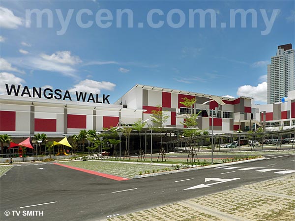
Info: The growing township of Wangsa Maju is now served by a brand new mall, in addition to Alpha Angle (Jusco) and Carrefour Wangsa Maju. Located on 10 acres of land, Wangsa Walk comprises 233,000 square feet of retail space and approximately 140 shops.
Wangsa Walk is developed and managed by MSL Properties Sdn Bhd (formerly Landmarks Land & Properties Sdn Bhd). MSL Properties is part owned by Singapore-listed MCL Land (http://www.mclland.com.sg/)
Nearby Landmarks: Carrefour (1), NZ Curry House (2), Pizza Hut & KFC (3)
Surrounding Places: Wangsa Link (4), Bangunan Zetro (5), Desa Setapak (Wangsa Maju Sec 2) (6), Desa Putra Condo (7), Wangsa Delima (8), Villa Wangsamas (villawangsamas) (9), Rampai Business Park (10), NSK Wholesale Supermarket (11), Sri Utama Private School (12), Royal Selangor (13), Wangsa Maju Immigration Office (14), Puspakom (15), JPJ KL (16), Wangsa Metroview Condo (17), Menara Alpha Condo (18), Tuanku Mizan Armed Forces Hospital - Hospital Angkatan Tentera (ATM) (HAT) - Army / Military Hospital (19), Balai Polis Wangsa Maju (20),
Menara Hidayah formerly
Menara Kausar (Hasil - Income Tax Office) (21), Jusco Alpha Angle Shopping Centre (22). Taman Sri Andaman Gated Townhouses (23), Villa TAR Condo (24), MyHome Hotel (25), Masjid Usamah Bin Zaid (26), Hotel Smile (27), Smart Hotel (28), Hotel Wangsa (29), Pasar & Pusat Penjaja Section 2 Wangsa Maju - Market & Hawkers' Centre (30), Rampai Court Condo (32), Tapak Pasar Malam Taman Sri Rampai - Night Market Site (33), Tapak Pasar Malam Setapak Jaya - Saturdays Night Market Site (34)
(use zoom and navigation buttons on top left of map to explore)
Surrounding Roads: Jalan Genting Kelang, Jalan 1/27A, Jalan 2/27A, Jalan 3/27A, Jalan 4/27A, Jalan 6/27A, Jalan 1/71A, Jalan 34/26, Jalan 15/27B, Jalan Metro Wangsa, Jalan Wangsa Melawati, Jalan Kilang, Jalan Usahawan, Jalan Rejang, Jalan Tumbuhan, Wangsa Maju Section 1, Wangsa Maju Section 2, Taman Sri Rampai, Taman Wangsa Melawati, Desa Setapak, Taman Bunga Raya
Nearby Hotels: My Home Hotel (25), Hotel Smile (27), Smart Hotel (28), Hotel Wangsa (29)
(For telephone contact, full address & web site of individual hotel, see our Hotel Listings)
Nearest Train Station: Wangsa Maju LRT Station, Setiawangsa LRT Station
Nearest Police Station: Balai Polis Wangsa Maju (20), Tel: 03 4149 2222
Bus Number:
Distance:
GPS Coordinates & Position: N3 11.931 E101 44.505
Featured Category: Shopping Malls
Related Categories: Real Estate Agents | Properties | Corporations
Connecting Maps: Immigration Office Taman Sri Rampai | Maybank Setapak | Royal Selangor
JPJ Wilayah Persekutuan | Wisma LJT, Taman Melawati | Wisma FELCRA
NSK Wholesale Market, Wangsa Maju | Platinum Hill, Taman Melati Utama |
|
|
| Find Other Places: Directions & Map Index | Search For A Location | More Maps Here |
Please help us refine the location information by sending additional info, suggestions, updates, comments to tvsmith@mycen.com.my
Maps powered by Google Maps unless otherwise stated. Additional geographical information, overlays, placemarks, waypoints, data, pictures and design created & owned by Malaysia Central & TV Smith. All rights reserved. No warranty on validity, completeness or accuracy given or implied. Use at your own risk. Property names, place names, location mark, point-of-interest, business names, designs, signs, graphics, symbols, icons, brands & logos are trademarks of their respective owners. |
| queries: photo, pics, image, gis, place, places, attraction, guide, streetmap, roadmap, building, site, streets, directory, roads, public transport, travel, get, go, going, getting, drive, driving, walk, direction, journey, lrt, ktm, cab, whereabouts, locate, about, how to go, where is, far, near, shortest, find, miles, from, lokasi, gambar, tempat, cari, cara, macam mana, di mana, bagaimana, pergi, ke, jalan, bangunan, wisma, teksi, peta, panduan, arahan, arah memandu, pandu, alamat, tapak, berdekatan, perjalanan, dari, laluan |
|
|
|
|