|
MyCen Directions: National Sports Complex, Bukit Jalil
|
Driving guide & ground directions with road maps, street pictures & information of the route, location or area
|
| Find Other Places: Directions & Map Index | Search For A Location | More Maps Here |
|
|
 MyCen Directions
Updated & Current
Clear & Accurate Maps
With Latest Landmarks
GPS Verified On Ground
Portal-Wide Useful Links
Picture Of Every Location
Comprehensive Information
Made With Local Knowledge
Each Place Visited In Person
Satellite & Google Earth View
Independent Opinion & Review

As Seen On TV's

|
Kompleks Sukan Negara, KSN
|
|
|
|
If interactive map above is slow to load or not showing, CLICK HERE for static view
|
|
|
|
|
| View the Full MyCen Events Calendar here |
|
Address: Bukit Jalil Sports Complex, Bukit Jalil, Kuala Lumpur, Malaysia
Postcode (Poskod): 57700 Kuala Lumpur
Tel: +603 8992 0888
Fax: +603 8994 4663
Website: http://www.stadium.gov.my/
Area: Wilayah Persekutuan Kuala Lumpur, Federal Territory of Kuala Lumpur (KL / WP)
Jurisdiction: Dewan Bandaraya Kuala Lumpur DBKL - KL City Hall (See Local Govt)
Directions: From the KL-Seremban Highway, turn into the MRR2 interchange and head towards the KESAS Highway. Exit at the Sri Petaling (Endah Parade) junction and turn left.
Events At This Location: See MyCen Events Calendar
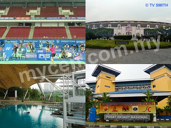
Info / Insights: The Bukit Jalil National Sports Complex (and the Bukit Kiara Sports Complex) is managed by Perbadanan Stadium Merdeka or PSM. The Bukit Jalil Sports Complex was conceived in 1994 and constructed in time for the Kuala Lumpur XVI Commonwealth Games in 1998.
The main jewel is the Bukit Jalil National Stadium (Stadium Nasional) with a seating capacity of 100,000 spectators. It replaced the Merdeka Stadium (and subsequently, the Shah Alam Stadium) as the premier stadium.
Next to it, is the Putra Stadium. Originally built for boxing, badminton, basketball, volleyball, tennis, fencing, handball, judo, wrestling and gymnastic events, it is now regularly used for concerts, musical shows and even equestrian events. It can seat about 15,000 spectators. The 2010 Thomas Cup & Uber Cup badminton matches are held here. Behind Stadium Putra is the smaller Dewan Sri Putra, also an indoor venue.
The neighbouring National Aquatic Centre (Pusat Akuatik Nasional) feature an olympic-size swimming pool, a diving pool and training pool. It has 4,000 permanent seats and can accommodate 2,000 more through temporary seating.
The National Squash Centre (Pusat Skuasy Nasional) has 10 size-modifiable courts. The center court has a seating capacity of 1000 and has been fittingly named the Nicol David Arena in October 2009.
Furthest away, is the National Hockey Stadium (Stadium Hoki Nasional) which comprises two stadiums. The main Stadium 1 (with 12,000 seating capacity) and the smaller Stadium 2 (with 2,000 seating capacity). It replaces the Tun Razak Hockey Stadium in Jalan Duta.
Behind the Hockey Stadium is a vast tract of land where the Extreme Park and Family Park used to be. They seem to be demolished for some reasons. Now, only a few open-air basketball and volleyball courts remain. The lonesome paintball park and golf driving range are still there at their respective corners.
Out in front, the headquarters of the Majlis Sukan Negara (National Sports Council), the Institut Sukan Negara (National Sports Institute) and a sports school make up the rest of the sprawling grounds.
Links:
Majlis Sukan Negara Malaysia MSN - National Sports Council (http://www.nsc.gov.my/)
Kementerian Belia & Sukan - Ministry Of Youth & Sport (http://www.kbs.gov.my/)
Proton-BWF Thomas & Uber Cup Badminton Finals 2010 (http://www.thomasuberkl2010.com/)
Nearby Landmarks: National Stadium (1), Putra Indoor Stadium (2), National Aquatic Centre (3), National Hockey Stadium (4), National Squash Centre (5)
Surrounding Places: Xtion Paintball Park (6), KSN Golf Driving Range (7), Bukit Komanwel Park (8), Indah Water Treatment Plant (9), Information Kiosk (10), Kafeteria (11), Dry Gim (12), Dewan Sri Putra (13), Majlis Sukan Negara Malaysia - MSN (14), Institut Sukan Negara (15), Sekolah Sukan Bukit Jalil - Sports School (16), Vista MSN Condo (17), Arena Green Condo (18),Vista Komanwel C Condo (20), Vista Komanwel B Condo (21), Vista Komanwel A Condo (22), Taman Esplanad (23), Bukit Jalil Golf & Country Resort (24), Savanna 2 Condo (25), International Medical University - IMU (26), Bukit Jalil Temporary Express Bus Terminal - Car Park F (27), Endah Parade Shopping Mall (28), Astro (29), Technology Park Malaysia - TPM (30)
(use zoom and navigation buttons on top left of map to explore)
Surrounding Roads: Jalan Merah Cagar, Lebuhraya Shah Alam (KESAS), KL-Seremban Highway, Lebuhraya Bukit Jalil-Puchong, MEX- KL Putrajaya Highway, Lebuhraya Sungei Besi
Nearby Hotels: Hotel Sri Petaling
(For telephone contact, full address & web site of individual hotel, see our Hotel Listings)
Nearest Train Station: Bukit Jalil LRT Station, Sri Petaling LRT Station
Nearest Police Station: Balai Polis Sri Petaling
Bus Number:
GPS Coordinates & Position: N3 03.277 E101 41.480
Featured Category : Venues
Related Categories: Sports | Event Managers | Events | News | Hotels
Connecting Maps: Terminal Bas Sementara Bukit Jalil | Sri Petaling Hotel |
|
|
| Find Other Places: Directions & Map Index | Search For A Location | More Maps Here |
Please help us refine the location information by sending additional info, suggestions, updates, comments to tvsmith@mycen.com.my
Maps powered by Google Maps unless otherwise stated. Additional geographical information, overlays, placemarks, waypoints, data, pictures and design created & owned by Malaysia Central & TV Smith. All rights reserved. No warranty on validity, completeness or accuracy given or implied. Use at your own risk. Property names, place names, location mark, point-of-interest, business names, designs, signs, graphics, symbols, icons, brands & logos are trademarks of their respective owners. |
| queries: photo, pics, image, gis, place, places, attraction, guide, streetmap, roadmap, building, site, streets, directory, roads, public transport, travel, get, go, going, getting, drive, driving, walk, direction, journey, lrt, ktm, cab, whereabouts, locate, about, how to go, where is, far, near, shortest, find, miles, from, lokasi, gambar, tempat, cari, cara, macam mana, di mana, bagaimana, pergi, ke, jalan, bangunan, wisma, teksi, peta, panduan, arahan, arah memandu, pandu, alamat, tapak, berdekatan, perjalanan, dari, laluan |
|
|
|
|